Wildlife Research Using Drones
North Star, in collaboration with Bright Wing, is a commercial UAS (Unmanned Aircraft Systems) company specializing in aerial data collection services. We utilize drone technology and remote sensing to collect actionable data for a variety of applications and industries. We offer affordable, high-resolution, aerial photography, videography, and photogrammetry.
Our drones can be configured with various payloads to collect your project data.
- Visual
- Thermal
- Near Infrared
- Multispectral
- Normalized Difference Vegetation Index (NDVI)
- Etc…you tell us
North Star and Bright Wing can provide the following deliverables:
- High-resolution aerial imagery and video
- Geolocated imagery
- Digital orthophoto maps
- 3D point-clouds
- 3D models
- Thermal data
- Plant health maps (NDVI)
- Digital surface models
- Elevation data
- Contour maps
- Volumetric data
Our datasets can be delivered in a variety of formats and are compatible with available software programs, including AutoCAD and ArcGIS. By combining drone data with powerful processing and analytics tools, we can provide valuable, on-demand data solutions to improve business performance and functionality. Our data collection process is broken down into four steps:
- Flight planning / data acquisition planning
- Conducting flight and collecting data
- Processing data
- Delivering product
In addition to providing drone services, North Star and Bright Wing can design, build, test, and deliver custom, mission-specific drone aircraft and payloads to meet our clients’ needs.
We offer on-site training for clients wanting to conduct drone operations in-house. Our training program covers everything you need to know about establishing a successful drone operation. Our goal is to get our clients in the air as quickly and efficiently as possible, while strongly emphasizing safety and legality. Topics include:
- UAS regulations and pilot certification
- Aircraft operations
- Choosing the best aircraft and sensors for your mission
- Data collection practices
- Insurance
- Managing your drone operation and streamlining workflows
- Data processing and analytics
North Star and Bright Wing have experience providing UAS services in the following industries:
- Construction
- Utilities
- Environmental
- Wildlife Research
- Mapping and surveying
- Real estate
- Marketing and advertising
- Insurance
With regard to wildlife research applications, drone technology (both fixed wing and copter) can be used in an ever increasing variety of ways, such as:
- Aeriel surveys
- Thermal imagery
- Nest examinations
- Habitat analysis and usage
- VHF tracking (extends receiving range)
- Cliff aerie examinations
Our pricing is based on a job-by-job basis, depending on clients needs. Please contact us to discuss your project and to get a quote, to schedule a job, or to inquire about our services.
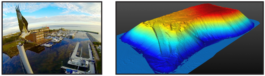
Spooked Osprey (left) and 3D Model derived from drone data (right)